
When contacting me about a particular photo(s),
always refer to the Post Date, Photo Number and Description.
[Photo #1 is always at the top of the posting]
Remember to Left-Click any photo to open a larger view,
then hit the ESC (escape) button on your keyboard
to return to the BLOG
then hit the ESC (escape) button on your keyboard
to return to the BLOG
As always, I hope you enjoy the view from above !!!
--------------------------------------------------------
 |
| #1 - Vast golf course with Saucon Creek running through near Center Valley, PA |
 |
| #2 - Unique semi-circular building complex at an unknown location |
 |
| #3 - The College of New Jersey in the city of Trenton |
 |
| #4 - The College of New Jersey and Sylva Lake in the city of Trenton |
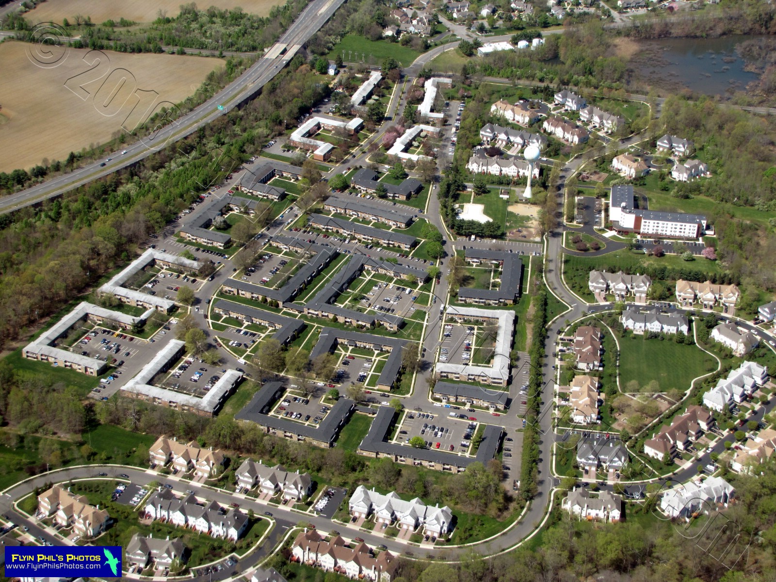 |
| #5 - Geometrically pleasing apartment complex near Trenton, NJ |
 |
| #6 - A new distribution warehouse along the New Jersey Turnpike in Cranbury, NJ |
 |
| #7 - New Jersey Turnpike and New Jersey State Police offices with heliport along the southbound side of the New Jersey Turnpike in Cranbury, NJ |
 |
| #8 - Office complex in Cranbury, NJ |
 |
| #9 - Fingers of plowed dirt amongst various offices/warehouses along the New Jersey Turnpike in Cranbury, NJ |
 |
| #10 - Lake Tarnofsky and IUOE Local 825 Training Center along the New Jersey Turnpike in Dayton, NJ |
 |
| #11 - Colorful tennis courts at Middlesex County College in Edison, NJ |
 |
| #12 - A ship travelling along the Arthur Kill prepares to pass underneath the Outerbridge Crossing (Route 440) linking Staten Island with Perth Amboy, NJ |
 |
| #13 - Numerous colorful shipping containers at this port in Perth Amboy, NJ |
 |
| #14 - Ships dock at this oil tank storage facility along the Arthur Kill in Port Reading, NJ |
 |
| #15 - The Arthur Kill Ship Graveyard, where ships go to die, in Staten Island, NY |
 |
| #16 - Looking north along the Arthur Kill with Newark, NJ in the distance |
 |
| #17 - Colorful rail cars along the Arthur Kill near Carteret, NJ |
 |
| #18 - Pergament Enterprises Shopping Mall in Staten Island, NY |
 |
| #19 - New Springville housing development near the Pergament Enterprises Mall in Staten Island, NY |
 |
| #20 - Abandoned Tuberculosis Hospital Complex, now the Staten Island Ballet School, in Staten Island, NY |
 |
| #21 - Abandoned Tuberculosis Hospital Complex, now the Staten Island Ballet School, in Staten Island, NY |
 |
| #22 - Stonegate at Grasmere housing complex along the Staten Island Expressway in Staten Island, NY |
 |
| #23 - Lower Manhattan Island (New York City) and the Upper Hudson Bay from Staten Island, NY, looking north |
 |
| #24 - Upper Hudson Bay and Lower Manhattan, New York City, NY, with many container ships |
 |
| #25 - Staten Island, NY side of the Verrazano-Narrows Bridge |
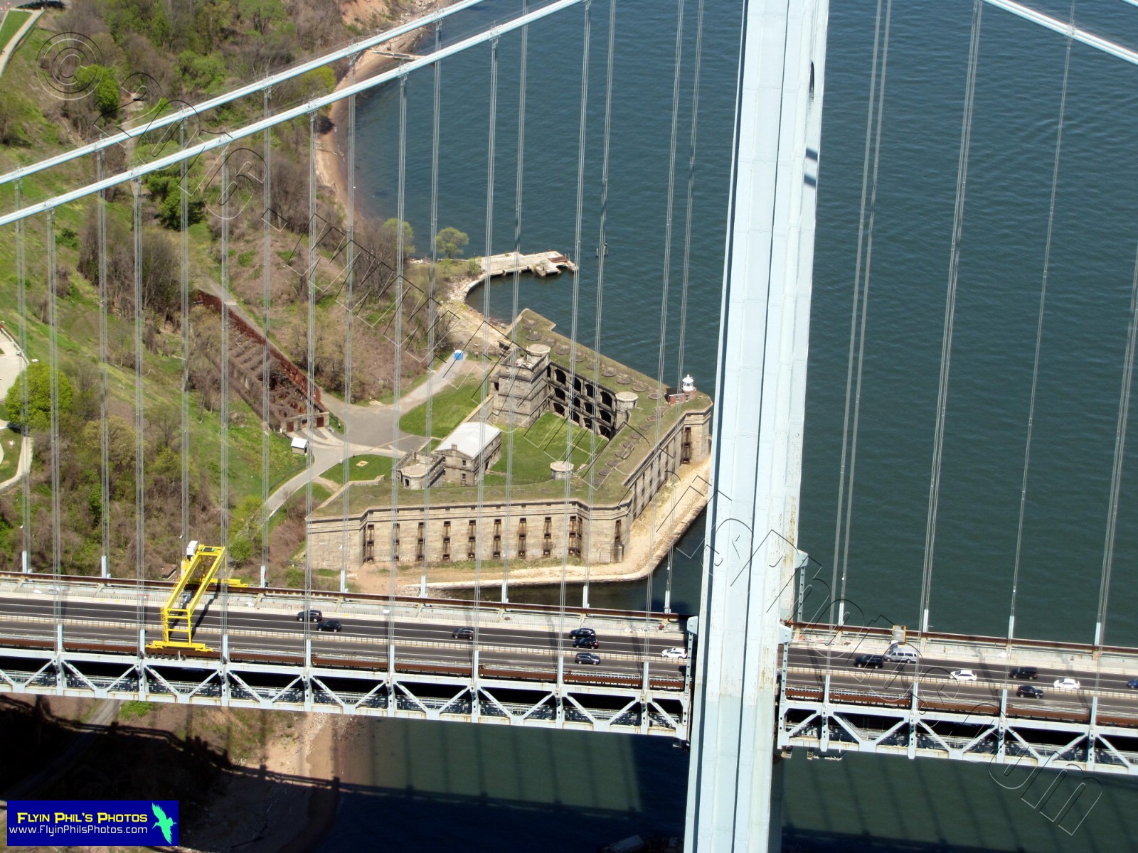 |
| #26 - Fort Wadsworth Light and Bunker can be seen through the Verrazano-Narrows Bridge on Staten Island, NY |
 |
| #27 - Fort Hamilton (upper left) and the I-278 / Belt Parkway interchange in Brooklyn, NY |
 |
| #28 - The I-278 / Belt Parkway interchange in Brooklyn, NY, under construction |
 |
| #29 - Fort Wadsworth adjacent to the Verrazono-Narrows Bridge in Staten Island, NY |
 |
| #30 - Fort Wadsworth adjacent to the Verrazono-Narrows Bridge in Staten Island, NY |
 |
| #31 - Verrazano-Narrows Bridge, looking southeast towards Brooklyn, NY |
 |
| #32 - Verrazano-Narrows Bridge, looking east towards Brooklyn, NY |
 |
| #33 - South Beach Treatment Addictions Center in Staten Island, NY |
 |
| #34 - Tottenville High School in Staten Island, NY |
 |
| #35 - Resurrection Cemetery in Staten Island, NY |
 |
| #36 - Outerbridge Crossing carrying Route 440 over the Arthur Kill near Perth Amboy, NJ and Staten Island, NY |
 |
| #37 - Harbortown Ports and Terrace Housing Complex in Perth Amboy, NJ |
 |
| #38 - State Fayette Apartment Complex (spells CIX) in Perth Amboy, NJ |
 |
| #39 - New Jersey Transit train station in Perth Amboy, NJ |
 |
| #40 - Traffic backed-up for miles traveling north on the Garden State Parkway near Cheesequake Creek and State Park in Matawan, NJ |
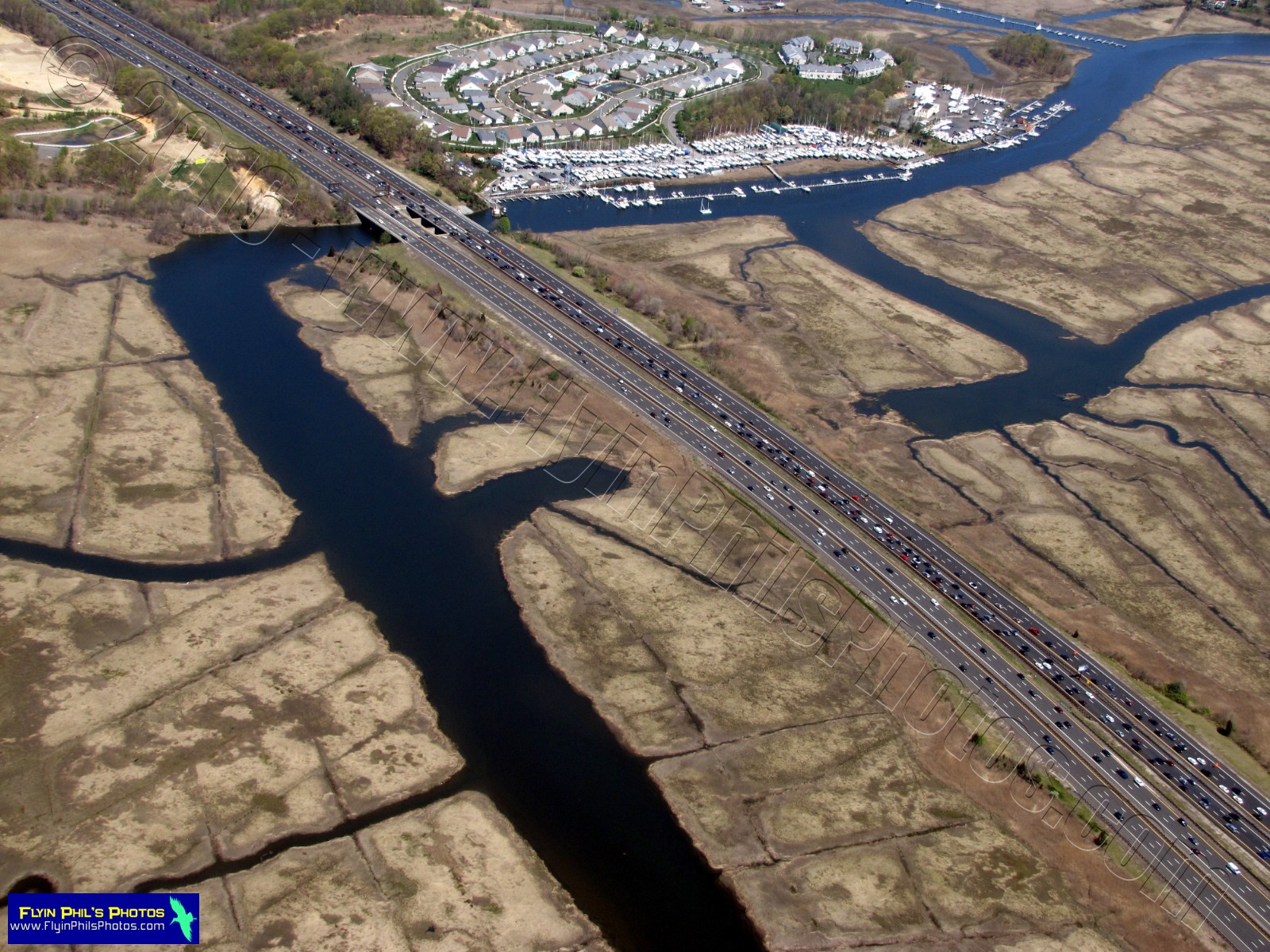 |
| #41 - Cheesequake Creek and the Garden State Parkway in Matawan, NJ |
 |
| #42 - Town of Red Bank, NJ, along the Navesink River |
 |
| #43 - Downtown (Broad Street) in Red Bank, NJ |
 |
| #44 - Town of Red Bank, NJ |
 |
| #45 - Downtown (Broad Street) in Red Bank, NJ |
 |
| #46 - Town of Red Bank, NJ, along the Navesink River |
 |
| #47 - Riverside Gardens Park in Red Bank, NJ |
 |
| #48 - Fancy homes adjacent to the Riverside Gardens Park in Red Bank, NJ |
 |
| #49 - Former Fort Monmouth (Army) in Eatontown, NJ |
 |
| #50 - Former Fort Monmouth (Army) in Eatontown, NJ |
 |
| #51 - Monmouth Mall at the intersection of Route 35 and 36 in Eatontown, NJ |
 |
| #52 - Clusters of town homes along Cotswold Circle in Ocean Township, NJ |
 |
| #53 - Clusters of town homes along Cotswold Circle in Ocean Township, NJ |
 |
| #54 - Rippled wall along the Garden State Parkway near Harvey Brook in Ocean Township, NJ |
 |
| #55 - Unique traffic "Circle" within another truncated "Circle" is the intersection of Route 66 and 35 in Neptune Township, NJ, |
 |
| #56 - Jersey Shore University Medical Center in Neptune City, NJ |
 |
| #57 - Looking east at Shark River and the Jersey Shore with Avon-By-The-Sea (left) and Belmar (right), NJ |
 |
| #58 - Spring Lake Golf Club in Spring Lake, NJ |
 |
| #59 - This traffic circle is the intersection of Route 35 and Atlantic Avenue in Mansquan, NJ |
 |
| #60 - Looking east at the Jersey Shore and the Manasquan Inlet with Point Pleasant (right) and Manasquan (left), NJ |
 |
| #61 - Manasquan Inlet along the Jersey Shore |
 |
| #62 - Manasquan River Golf Course in Brielle, NJ, with Ellis Point protruding into the Manasquan River |
 |
| #63 - Osborn Island on the Manasquan River, looking east at the Jersey Shore and Point Pleasant, NJ |
 |
| #64 - Osborn Island on the Manasquan River near Point Pleasant, NJ |
 |
| #65 - "Floating" residential properties along Northeast Drive and Joie Place in Brick, NJ |
 |
| #66 - Green Cove Marina on the Metedeconk River in Brick, NJ |
 |
| #67 - Looking south at many retail stores in Brick, NJ |
 |
| #68 - Numerous retail shops in this Brick, NJ, shopping center at the intersection of Hooper Avenue, Route 35 and 70 |
 |
| #69 - Cedar Bridge Branch river runs through a portion of the parking lot of this shopping center in Brick, NJ |
 |
| #70 - The Church of Grace and Peace along Old Freehold Road and adjacent to the Garden State Parkway in Toms River, NJ |
 |
| #71 - Pine trees dot this clearing in the Pine Barrens near Bayville, NJ |
 |
| #72 - This home's backyard is a pond along Butler Boulevard in Bayville, NJ |
 |
| #73 - Whitey's Landing and Butler Beach on the Barnegat Bay in Bayville, NJ |
 |
| #74 - Looking north across the Barnegat Bay at the Route 37 bridge into Seaside Heights, NJ (right) and the Jersey Shore |
 |
| #75 - The Barnegat Bay waters were clear today and you could see straight through to the various sandy formations below, near Bayville, NJ |
 |
| #76 - The Jersey Shore, looking at Seaside Heights and points north to Sandy Hook, NJ |
 |
| #77 - This section of Island Beach State Park lies just beyond the park's entrance at the southern end of Seaside Park, NJ |
 |
| #78 - Island Beach State Park along the Jersey Shore |
 |
| #79 - One lonely boat at Tices Shoal, a boater's paradise on the Barnegat Bay side of Island Beach State Park along the Jersey Shore |
 |
| #80 - Mallard Yacht Club along Route 72 and Cedar Creek in Manahawkin, NJ |
 |
| #81 - The massive Beach Haven West housing complex along Route 72 in Manahawkin, NJ |
 |
| #82 - A. Paul King Park beach on Manahawkin Lake at the intersection of Route 72 and 9 in Manahawkin, NJ |
 |
| #83 - What looks like a simple gathering of big name stores is really the location of the former Manahawkin airport (smack dab where the Walmart is today; big, white roof) in Manahawkin, NJ |
 |
| #84 - A complicated looking housing development northwest of the intersection of the Garden State Parkway and Route 72 in Manahawkin, NJ |
 |
| #85 - Ah, the Pine Barrens, a vast area of mainly pine trees and scrub pine bushes. This area in particular is in Barnegat Township, NJ |
 |
| #86 - The New Jersey Pine Barrens in and area along Route 72 in Barnegat Township, NJ, looking south |
 |
| #87 - Coyle Field private use airport utilized by the military in Barnegat, NJ |
 |
| #88 - Coyle Field in Barnegat, NJ, consists of long, dirt/sand runways in the middle of the New Jersey Pine Barrens |
 |
| #89 - Strange gathering of clearings in the Pine Barrens north of Route 72 in Barnegat, NJ |
 |
| #90 - Shapes cut-out from the New Jersey Pine Barrens look like letters from the alphabet... But what can they be trying to tell us, and did aliens from another world create them ??? This area happens to be north of Route 72 and Barnegat, NJ |
 |
| #91 - A mix of deciduous and pine trees in an area near Deep Run in Tabernacle, NJ |
 |
| #92 - The North Branch of the Rancocas Creek, looking northeast, in Mt Holly, NJ |
 |
| #93 - Hampton Behavioral Health Center in Westhampton, NJ |
 |
| #94 - Tabernacle Baptist Church in Burlington, NJ |
 |
| #95 - Burlington Bristol Bridge crossing the Delaware River, looking south |
 |
| #96 - Margaret R. Grundy Memorial Library along the Delaware River in Bristol, PA |
 |
| #97 - I-276 bridge over the Delaware River near Burlington, NJ |
 |
| #98 - Brilliant yellow storage tanks on Riverside Industrial Park Drive along the Delaware River in Bristol, PA |
 |
| #99 - Large ships for scrap removal along the Delaware River near Morrisville, PA |
 |
| #100 - Large ships for scrap removal along the Delaware River near Morrisville, PA |
 |
| #101 - Piles of scrap wait to be loaded into large ships on the Delaware River near Morrisville, PA |
 |
| #102 - Piles of scrap wait to be loaded into large ships on the Delaware River near Morrisville, PA |
 |
| #103 - Piles of scrap wait to be loaded into large ships on the Delaware River near Morrisville, PA |
 |
| #104 - Cranes aboard this large ship on the Delaware River near Morrisville, PA, load scrap into giant storage areas |
 |
| #105 - Intricate marsh land between I-195 and the Delaware River, south of Trenton, NJ |
 |
| #106 - Hamilton Township Sanitary Sewer waste water treatment facility along I-195 in Trenton, NJ |
 |
| #107 - A mix of colorful, large and small tanks at the Hamilton Township Sanitary Sewer waste water treatment facility along I-195 in Trenton, NJ |
 |
| #108 - Homes along Ettl Circle in Princeton, NJ |
 |
| #109 - This large residential property is on the northwest side of the Sourland Mountain near Amwell Township, NJ |
 |
| #110 - This large residential property is on the northwest side of the Sourland Mountain near Amwell Township, N |
 |
| #111 - Bright green Spring fields in Ringoes, NJ |
 |
| #112 - Fresh green Spring fields and rows of deciduous trees without leaves near Ringoes, NJ |
 |
| #113 - Diamond Nation training complex for baseball and softball in Flemington, NJ |
 |
| #114 - Diamond Nation training complex for baseball and softball in Flemington, NJ |
 |
| #115 - Hunterdon Care Center in Flemington, NJ |
 |
| #116 - A patchwork of solar panels atop this Walmart in Flemington, NJ |
 |
| #117 - A disturbed array of truck trailers along Minneakoning Road in Flemington, NJ |
 |
| #118 - These truck trailers in Flemington, NJ, were once tightly packed but are now scattered about...Why, you ask? Who knows !!! |
 |
| #119 - Eastern portion of Round Valley Reservoir in Clinton, NJ, looking east |
 |
| #120 - Pink walls and a blue roof on Union Township Elementary School in Hampton, NJ |
--------------------------------------------------------
See you after the next flight...