
When contacting me about a particular photo(s),
always refer to the Post Date, Photo Number and Description.
[Photo #1 is always at the top of the posting]
Remember to Left-Click any photo to open a larger view,
then hit the ESC (escape) button on your keyboard
to return to the BLOG
then hit the ESC (escape) button on your keyboard
to return to the BLOG
--------------------------------------------------------
Hi everyone and welcome to another smorgasbord of Aerial Photography, (63) photos in all, the most I believe I have ever featured in a Highlights post thus far. The reason being is that the flight included a climb to nearly 8,000 feet over
New York City for a look around town, so to speak, and the surrounding area.
As we climbed through 5,000 feet we cleared a scattered cloud deck, and continuing to climb higher the air became eerily still, perfect for shooting aerial photos. Towards the end of the day, the skies became more overcast with very little breaks of sun, especially towards the Jersey Shore, as you will soon see.
As always, I hope you enjoy the view from above !!!
 |
| #1 - Strange markings in a field near Princeton, NJ |
 |
| #2 - Garden State Parkway, Route 9 & Route 35 crossing the Raritan River in New Jersey |
 |
| #3 - Staten Island and the Arthur Kill, looking west |
 |
| #4 - Oil Storage Tanks along the Arthur Kill in Staten Island, looking west |
 |
| #5 - Looking east at the south shore of Long Island, New York |
 |
| #6 - Staten Island, looking west |
 |
| #7 - Shipping docks just east of Newark International Airport along Newark Bay |
 |
| #8 - Lower Manhattan, looking northeast |
 |
| #9 - Statue of Liberty in Upper New York Bay |
 |
| #10 - Ellis Island in Upper New York Bay |
 |
| #11 - Jersey City, New Jersey, looking northwest |
 |
| #12 - Ground Zero in lower Manhattan and construction of the new Freedom Tower |
 |
| #13 - Ground Zero in lower Manhattan and construction of the new Freedom Tower |
 |
| #14 - Ground Zero in lower Manhattan and construction of the new Freedom Tower |
 |
| #15 - Lower Manhattan and the new Freedom Tower @ Ground Zero at right |
 |
| #16 - Brooklyn & Manhattan Bridges over the East river in New York City |
 |
| #17 - Manhattan, looking north |
 |
| #18 - Midtown Manhattan, looking west |
 |
| #19 - 59th Street Bridge over Roosevelt Island and the East River |
 |
| #20 - Midtown Manhattan, looking west |
 |
| #21 - New Jersey side of the George Washington Bridge over the Hudson River |
 |
| #22 - La Guardia Airport, looking east towards Long Island, New York |
 |
| #23 - Tri-borough (left) and Willis Avenue (right) Bridges over the Harlem River |
 |
| #24 - Yankee Stadium in the Bronx |
 |
| #25 - Bronx area of New York City, looking west |
 |
| #26 - Bronx area of New York City, looking west |
 |
| #27 - New York Botanical Gardens in the Bronx |
 |
| #28 - Broadway (near) & the Henry Hudson Parkway (far) Bridges over the Harlem River |
 |
| #29 - Subway / Rail Yard in the Mount Vernon area of New York City |
 |
| #30 - Yonkers Raceway |
 |
| #31 - Neat cloud hovering over White Plains, looking northwest |
 |
| #32 - City of White Plains, looking northwest |
 |
| #33 - Westchester County airport, White Plains, NY |
 |
| #34 - South shore of Connecticut, looking south at the Long Island Sound |
 |
| #35 - South shore of Connecticut, looking south at the Long Island Sound |
 |
| #36 - Danbury Airport, Danbury, CT (looking north) |
 |
| #37 - Interesting looking building complex on Long Island, NY |
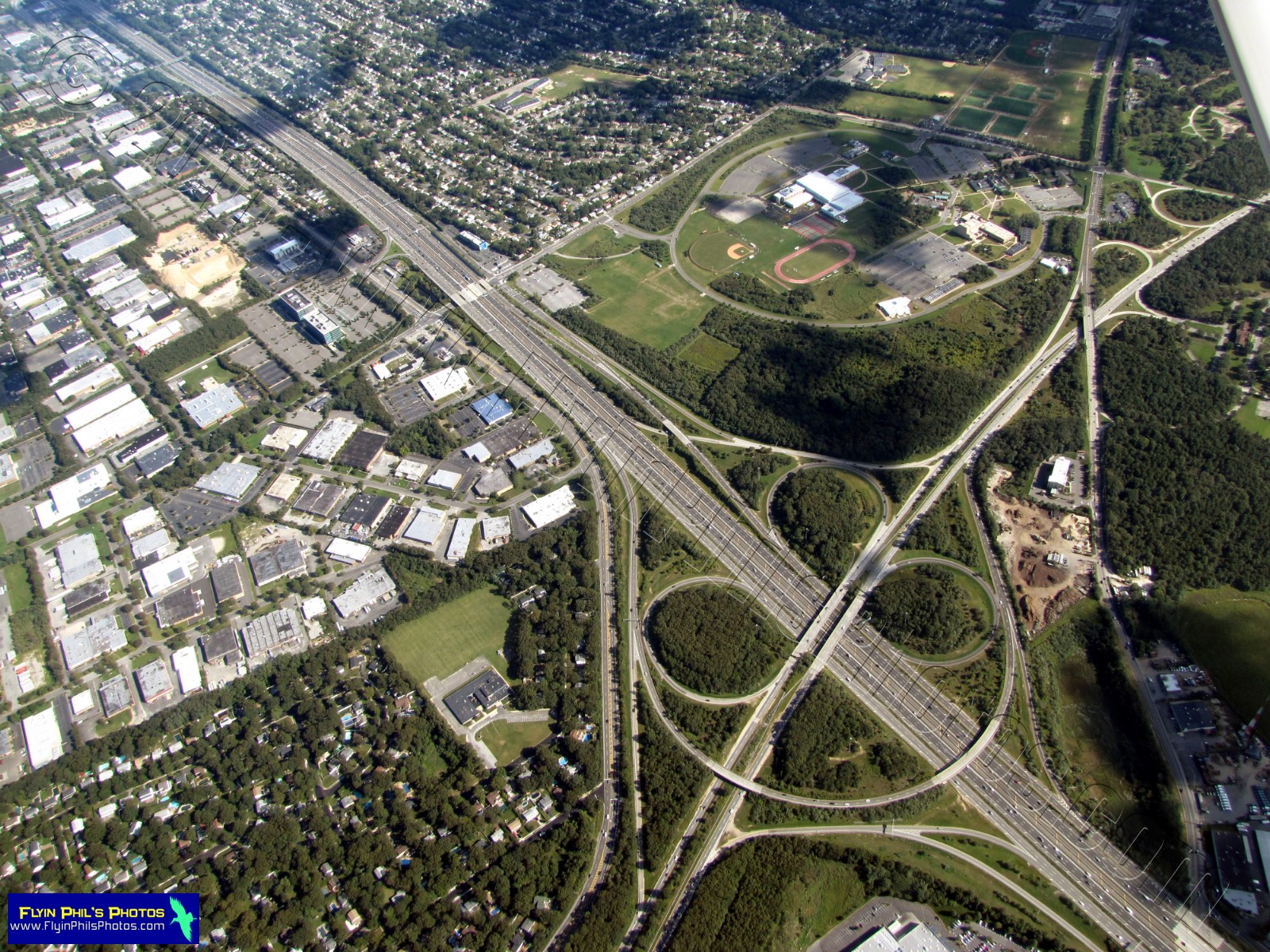 |
| #38 - Impressive highway interchange on Long Island, NY |
 |
| #39 - Looking south towards Jones Beach on Long Island. Note my custom Aerial Video unit mounted on the wing strut |
 |
| #40 - Enormous cemetery on Long Island, NY |
 |
| #41 - Parking lot at Jones Beach, Long Island, NY |
 |
| #42 - Parking lots at Jones Beach, Long Island, NY |
 |
| #43 - Beach area along the south shore of Long Island |
 |
| #44 - Long Beach on Long Island, New York, looking northwest |
 |
| #45 - Aircraft landing at JFK International Airport with the Manhattan skyline in the distance |
 |
| #46 - Far Rockaway, New York, looking northeast |
 |
| #47 - Aircraft on Final Approach for JFK International Airport, looking west |
 |
| #48 - Rockaway Beach on Long Island, NY, looking north, with the Manhattan skyline in the distance |
 |
| #49 - Coney Island amusement area, New York |
 |
| #50 - Island in the Lower New York Bay, south of the Verrazano Bridge |
 |
| #51 - Housing development near Jamesburg, NJ |
 |
| #52 - Corporation near Princeton, NJ |
 |
| #53 - Corporation near Princeton, NJ |
 |
| #54 - Unusual raised area behind a home in Hopewell, NJ |
 |
| #55 - Farm fields in Hunterdon County, NJ |
 |
| #56 - Rail yard in Ringoes, NJ |
 |
| #57 - Lush, green farm field in Hunterdon County, NJ |
 |
| #58 - "Dotted" farm field in Hunterdon County, NJ |
 |
| #59 - Private airstrip in Hunterdon County, NJ |
 |
| #60 - New solar farm construction in Hunterdon County, NJ |
 |
| #61 - Solar farm in Hunterdon County, NJ |
 |
| #62 - Lush farm fields of Hunterdon County, NJ, with the Delaware river in the distance |
 |
| #63 - A gem of a home amongst lush green fields in Hunterdon County, NJ |
--------------------------------------------------------
I sure hope you enjoyed this epic flight over the Greater New York City area,
as well as over picturesque Hunterdon County, New Jersey.
--------------------------------------------------------
See you after the next flight...


