
When contacting me about a particular photo(s),
always refer to the Post Date, Photo Number and Description.
[Photo #1 is always at the top of the posting]
Remember to Left-Click any photo to open a larger view,
then hit the ESC (escape) button on your keyboard
to return to the BLOG
then hit the ESC (escape) button on your keyboard
to return to the BLOG
--------------------------------------------------------
Welcome to my first 2016 winter flight. After a seven week hiatus due to ever changing weather conditions unsuitable for pleasure flying on a Sunday, it felt good to stretch my wings, so to speak. And with the snow
only partially covering the ground, each view was extremely
pronounced with various dark and light hues and various
shadow present. All photos were shot within the states
of New Jersey and Pennsylvania.
As always, I hope you enjoy the view from above
only partially covering the ground, each view was extremely
pronounced with various dark and light hues and various
shadow present. All photos were shot within the states
of New Jersey and Pennsylvania.
As always, I hope you enjoy the view from above
--------------------------------------------------------
 |
| #1 - Alexandria (N85), northwest of Pittstown |
 |
| #2 - Looking north at Round Valley Reservoir in the distance with Flemington, NJ to the left, both in Hunterdon County |
 |
| #3 - This landscape is west of Hillsborough, NJ |
 |
| #4 - Clusters of town homes in Hillsborough, NJ |
 |
| #5 - City of New Brunswick, NJ, looking north with the Raritan River to the right |
 |
| #6 - Interchange of Route 1 and Ryders Lane in New Brunswick, NJ |
 |
| #7 - New Jersey Turnpike crossing the Raritan River in Highland Park, NJ |
 |
| #8 - This is all that's left of a factory in Highland Park, NJ, adjacent to the New Jersey Turnpike |
 |
| #9 - Alfred E. Driscoll Bridge (left) carrying both the Garden State Parkway and Route 9 along with the Convery Road / Route 35 Bridge |
 |
| #10 - Middlesex County Utilities in South Amboy, NJ |
 |
| #11 - Cornucopia Cruise Lines in Perth Amboy on the Raritan River |
 |
| #12 - Outerbridge Crossing linking Perth Amboy, NJ (left) with Staten Island, NY |
 |
| #13 - Colorful shipping containers and white oil tanks north of Perth Amboy, NJ |
 |
| #14 - End of the line for Route 440 and the West Shore Expressway in Staten Island, NY (looking north) |
 |
| #15 - Verrazano-Narrows Bridge and Manhattan, New York City, NY (looking north) |
 |
| #16 - No, this is not a head of a moose, but rather the northernmost tip of The Jersey Shore, Sandy Hook, NJ |
 |
| #17 - Winter boat storage near Sea Bright, NJ |
 |
| #18 - Jersey Shore homes in Deal, NJ |
 |
| #19 - The partial snow-covered ground made for some very intricate landscapes along the Jersey Shore, this one Deal, NJ |
 |
| #20 - Convention Hall on the Asbury Park, NJ boardwalk |
 |
| #21 - Casino on the Asbury Park, NJ boardwalk, once home to the Merry-Go-Round |
 |
| #22 - Densely packed town homes adjacent to the Asbury Park, NJ boardwalk, with Wesley Lake to the right |
 |
| #23 - Fletcher Lake with Ocean Grove (upper-left) and Bradley Beach, (lower-right), both along the Jersey Shore |
 |
| #24 - Lake Como midway between Belmar (left) and Spring Lake (right), both along The Jersey Shore |
 |
| #25 - Crescent Park in Sea Girt, NJ |
 |
| #26 - Manasquan Inlet with Point Pleasant, NJ to the right |
 |
| #27 - Lake Louise along The Jersey Shore in Point Pleasant, NJ |
 |
| #28 - Point Pleasant, NJ |
 |
| #29 - Jenkinson's Aquarium (left; pink building) and Boardwalk in Point Pleasant, NJ |
 |
| #30 - Follow the Finger within Lake of the Lillies in Point Pleasant Beach, NJ |
 |
| #31 - Yes, the Finger points to The Jersey Shore and Point Pleasant |
 |
| #32 - Point Pleasant Canal linking the Manasquan River (top) with Bay Head Harbor (bottom; not shown), at the northernmost tip of the Barnegat Bay |
 |
| #33 - The Jersey Shore, looking south at Lavallette and Seaside Heights |
 |
| #34 - Icy coves in Mantaloking, NJ |
 |
| #35 - Chadwick Beach Island, just north of Seaside Heights, NJ, along The Jersey Shore |
 |
| #36 - Middle Sedge adjacent to Chadwick Beach Island, NJ |
 |
| #37 - This abandoned home sits on a spit of land west of Middle Sedge in the Barnegat Bay |
 |
| #38 - The abandoned home can be seen to the center-left, sitting on a spit of land west of Middle Sedge in the Barnegat Bay |
 |
| #39 - Goose Creek flows through this undeveloped area of Toms River, NJ |
 |
| #40 - Circular housing complex within a checkerboard layout in Gilford Park, east of Toms River, NJ |
 |
| #41 - Only a small portion of Holiday City senior housing complex in Toms River, NJ (looking south) |
 |
| #42 - Ocean County Airport (MJX) in Toms River, NJ |
 |
| #43 - Goodluck Point in Toms River, NJ, looking east at Seaside Heights |
 |
| #44 - Former ATT building on Goodluck Point in Toms River, NJ, part of what used to be an AT&T communications facility |
 |
| #45 - Goodluck Point, Barnegat Bay and the Route 37 bridge crossing from Toms River to Seaside Heights, NJ |
 |
| #46 - The Jersey Shore, from the entrance to Island Beach State Park north to Mantaloking (sorry about the sun glare) |
 |
| #47 - Route 37 bridge and Pelican Island in Seaside Heights, NJ |
 |
| #48 - Looking south at a portion of Island Beach State Park and the Barnegat Bay |
 |
| #49 - Seaside Heights boardwalk and Casino Pier (lower) along The Jersey Shore |
 |
| #50 - Seaside Heights boardwalk and Casino Pier (lower) along The Jersey Shore |
 |
| #51 - Looking south at the Barnegat Bay, Pelican Island and Seaside Heights/Island Beach State Park, NJ |
 |
| #52 - Looking south at Harbor Island, Barnegat Bay and Pelican Island in Seaside Heights, NJ |
 |
| #53 - A "pine forest claw" at a residential complex in Toms River, NJ |
 |
| #54 - Greenbriar Woodlands adult community in Toms River, NJ |
 |
| #55 - Westlake Golf and Country Club in Jackson, NJ |
--------------------------------------------------------
The following (4) photos are of Six Flags Great Adventure
Theme Park in Jackson, NJ
 |
| #56 - Nitro coaster at Six Flags Great Adventure |
 |
| #57 - New construction of "The Joker" free-fly coaster at Six Flags Great Adventure |
 |
| #58 - "The Joker" free-fly coaster construction along Prospertown Lake at Six Flags Great Adventure |
 |
| #59 - The towering "Kingda Ka" coaster at Six Flags Great Adventure |
--------------------------------------------------------
 |
| #60 - Horse farm and small, enclosed track in Allentown, NJ |
 |
| #61 - Kube-Pak, growers of fine garden plants, in Allentown, NJ |
 |
| #62 - Hamilton Marketplace in Hamilton Township, NJ, glistens from all of the snow melt (looking south, with Route 130 to the right) |
 |
| #63 - Mercer Lake and Mercer Oaks Golf in Princeton Junction, NJ |
 |
| #64 - Mercer Oaks Golf along the northern shore of Mercer Lake in Princeton Junction, NJ |
 |
| #65 - Looking southwest at all roads leading to Trenton, NJ, the State Capitol |
 |
| #66 - The quiet hamlet of Point Pleasant, PA, along the shore of the Delaware River |
 |
| #67 - New bridge construction over Tohickon Creek in Point Pleasant, PA |
 |
| #68 - F.P. Kolbe unique gifts and accessories in Point Pleasant, PA |
 |
| #69 - Looking north from Point Pleasant, PA, along the Delaware River with New Jersey to the right |
 |
| #70 - Looking south along Tohickon Creek at Point Pleasant, PA, and the Delaware River to the left |
 |
| #71 - High Rocks Vista within Ralph Stover State Park along with Tohickon Creek in Pipersville, PA |
 |
| #72 - All aircraft are "snowed-in" at Vansant (9N1) airport in Erwinna, PA |
 |
| #73 - Late afternoon sun makes Lake Nockamixon in Quakertown, PA come alive with various hues (looking southwest) |
 |
| #74 - Volendam Windmill in Holland Township, NJ |
 |
| #75 - City of Easton, PA (top and left) and Phillipsburg, NJ (right) with the Delaware River dividing the two |
 |
| #76 - Route 22 toll bridge over the Delaware River near Easton, PA and Phillipsburg, NJ |
 |
| #77 - A patchwork of snow-covered farm fields north of Nazareth, PA |
 |
| #78 - Martins Creek Power Plant in Martins Creek, PA, along the Delaware River |
 |
| #79 - Twin stacks at Martins Creek Power Plant in Martins Creek, PA |
 |
| #80 - Mini steam stacks at Martins Creek Power Plant in Martins Creek, PA |
 |
| #81 - The Kittatinny Mountain Ridge as seen from just east of the Delaware Water Gap looks like a giant "snake" traversing its way southwest |
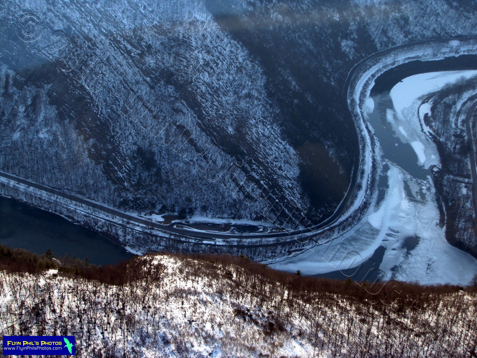 |
| #82 - An icy Delaware River within the Delaware Water Gap |
 |
| #83 - The Delaware Water Gap with Interstate 80 and the Delaware River running through (looking east towards New Jersey) |
 |
| #84 - The Delaware Water Gap with Interstate 80 and the Delaware River running through (looking north along the Kittatinny Ridge) |
 |
| #85 - Arrow Island on the Delaware River just east of the Delaware Water Gap |
 |
| #86 - Paulinskill Viaduct, a former railroad bridge in Hainesburg, NJ |
 |
| #87 - A creek in northern New Jersey that could not make up its mind which direction it wanted to flow |
 |
| #88 - This farm field in northern New Jersey comes complete with a beer bottle and label |
 |
| #89 - Unusual shapes of melting ice on Mountain Lake, north of Buttzville, NJ |
 |
| #90 - A sprawling estate in northern New Jersey |
 |
| #91 - A narrow junkyard near Washington, NJ |
 |
| #92 - Looking southwest along the valley running from Washington to Bloomsbury, both towns in New Jersey |
 |
| #93 - Tree nursery near Glen Gardner, NJ |
 |
| #94 - Spruce Run Lutheran Church in Glen Gardner, NJ |
 |
| #95 - Former Hagedorn Psychiatric Hospital in Glen Gardner, NJ, now permanently CLOSED |
 |
| #96 - The small town of High Bridge, NJ, looking northeast) |
 |
| #97 - High Bridge, NJ |
 |
| #98 - Looking south along Main Street in High Bridge, NJ |
 |
| #99 - An ice-covered Spruce Run Reservoir in Clinton, NJ (looking west) |
 |
| #100 - Round Valley Reservoir in Clinton Township, NJ |
--------------------------------------------------------
See you after the next flight...