Search for "Flight Highlights" Aerial Photos HERE:

Showing posts with label cliff. Show all posts

Monday, November 24, 2014

From a Flight on Sunday, November 23, 2014...


When contacting me about a particular photo(s),
always refer to the Post Date, Photo Number and Description.

[Photo #1 is always at the top of the posting]

Remember to Left-Click any photo to open a larger view,
then hit the ESC (escape) button on your keyboard
to return to the BLOG

--------------------------------------------------------

Not much to say except that today's flight has shown us the last
of the beautiful fall colors that the northeast has to offer.

As always, I hope you enjoy the view from above...

--------------------------------------------------------
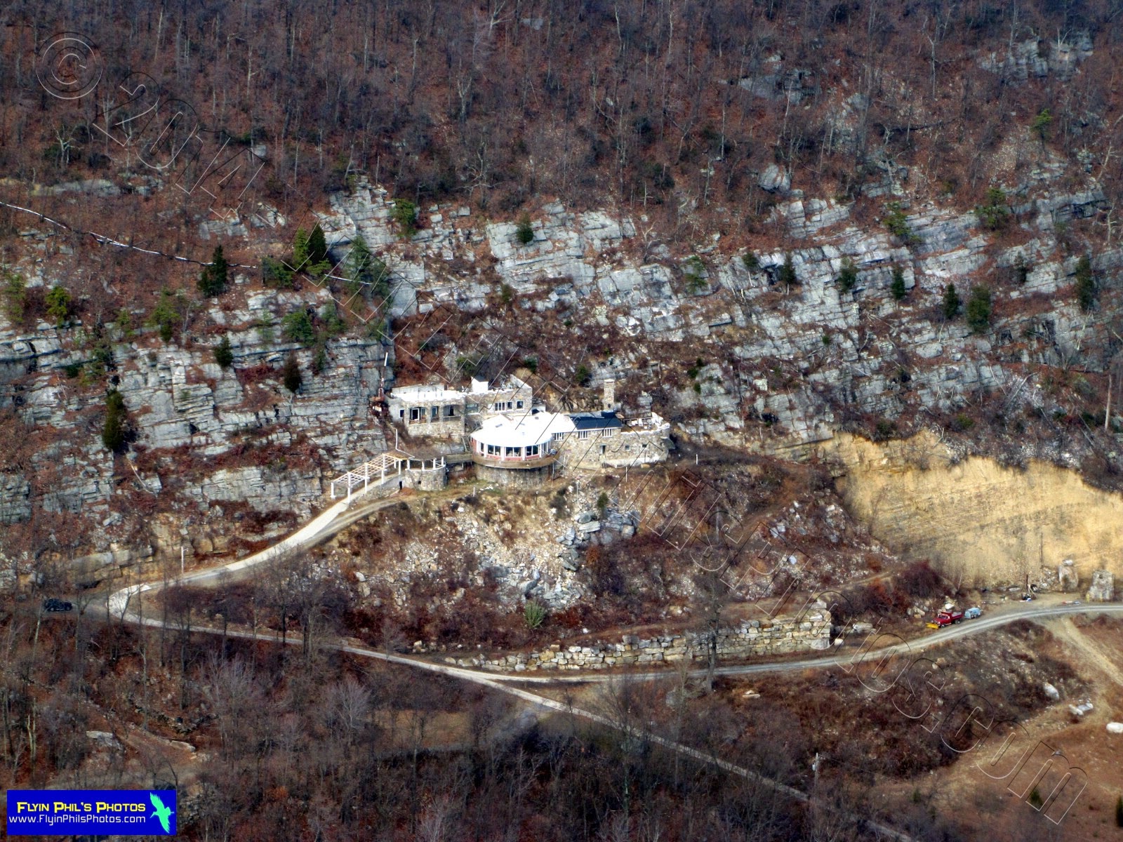
#1 - Unknown Stone Structure north
of Bangor, PA

#2 - Large Cave adjacent to Stone
Structure north of Bangor, PA

#3 - Blair Academy in Blairstown, NJ

#4 - Blair Academy in Blairstown, NJ

#5 - Colorful buildings under
construction near Blairstown, NJ

#6 - Swampy area south of
Newton, NJ

#7 - Andover airport nestled between
two lakes within Kittatinny Valley
State Park in Andover, NJ

#8 - Andover airport is very picturesque

#9 - Kittatinny Ridge just south of
the Delaware Water Gap in PA
(shot with my GoPro HERO3+)

#10 - Kittatinny ridge just north of
the Delaware Water Gap in NJ
(shot with my GoPro HERO3+)

#11 - Lake Hopatcong, NJ,
looking east
(shot with my GoPro HERO3+)

#12 - Lake Hopatcong, NJ,
looking northeast
(shot with my GoPro HERO3+)

#13 - Unique, circular housing
development near
Lake Hopatcong, NJ

#14 - One of a few inhabited
islands on Lake Hopatcong, NJ
with no bridge access

#15 - Lake Hopatcong, NJ,
looking north
(shot with my GoPro HERO3+)
#16 - Lake Hopatcong, NJ,
looking north
(shot with my GoPro HERO3+)
#17 - The Jefferson House
restaurant on Lake Hopatcong, NJ

#18 - The Jefferson House
restaurant on Lake Hopatcong, NJ

#19 - Nolans's Point and a new
Mini-Golf course on
Lake Hopatcong, NJ

#20 - Ice sheet formations on
Lake Musconetcong, NJ

#21 - Ice sheet formations on
Lake Musconetcong, NJ

#22 - Round Valley reservoir,
east of Clinton, NJ
(shot with my GoPro HERO3+)
#23 - Fields being watered in
late November (interesting ???),
near Clinton, NJ

#24 - Historic town of Clinton, NJ

#25 - Historic town of Clinton, NJ

#26 - Spruce Run reservoir
(looking east) near Clinton, NJ

#27 - Hot air balloon drifting north
of Sky Manor airport near
Pittstown, NJ

#28 - Looks like the balloon is on fire!

#29 - Private residence nestled
amongst many picturesque pines,
northeast of Frenchtown, NJ

#30 - A small Cessna 150 has managed
to crash land on this corn field, only
a few hundred feet east of Sky Manor
airport in Pittstown, NJ

#31 - And here lies the small Cessna
in a cornfield at the end of
runway 7 at Sky Manor airport.
It had crashed in t
he summer months
when the 
corn was high and able to cushion
the crash, which is why there are
no skid marks...
 
Thanks for stopping by and see you after the next flight...

In the mean time, I wish you a...


HAPPY THANKSGIVING !!!
 

Wednesday, May 1, 2013

From a Flight on Sunday, April 28, 2013...


When contacting me about a particular photo(s),
always refer to the Post Date, Photo Number and Description.

[Photo #1 is always at the top of the posting]

Remember to Left-Click any photo to open a larger view,
then hit the ESC (escape) button on your keyboard
to return to the BLOG

--------------------------------------------------------

Today's flight encompassed northern New Jersey and
the Lower Hudson Valley of New York.  On the return trip, we flew
south along the Hudson river past West Point military academy.
It was an unusually hazy and turbulent flying day, but the
impressive views made-up for these conditions. 

As always, I hope you enjoy the view from above !!!

----------------------------------------------

#1 - Sprawling estate northwest of Pittstown, NJ

#2 - Unusually shaped home north of Clinton, NJ

#3 - "Crop-Circles", or not, near Washington, NJ

#4 - Wow, what an entrance to
this home north of Washington, NJ

#5 - Looks like someone has plans for
a hillside housing development,
just west of Hackettstown, NJ

#6 - Eastern most section of Panther Valley
Country Club and housing development,
north of Hackettstown, NJ

#7 - Just another pretty farm
in rural northwest NJ

#8 - A new solar field and
industrial complex under construction
near Franklin, NJ

#9 - Vast orchards, looking east towards
the Hudson river south Poughkeepsie, NY

#10 - Cement plant along the Hudson river
south of Poughkeepsie, NY

----------------------------------------------
 The following (3) photos are of a small island
smack-dab in the middle of the Hudson river,
just south of Newburgh, NY, between
Storm King & Hudson Highlands State Parks.
The ruins of an old castle are still present,
as well as other structures.
 
#11

#12

#13

----------------------------------------------

#14 - Terraced housing units south of
West Point military academy

#15 - West Point military academy, NY,
along the Hudson river

#16 - Indian Point nuclear power
generating station on the Hudson River

#17 - This photo and the next show an area
north of Suffern, NY.  Within the rugged
and hilly terrain, there exists a circular
structure with a dilapidated roof.  Your guess
is as good as mine as to just what this was
used for, as there are no access roads
that I can see.

#18 - Just what was this interesting
structure used for?

#19 - Clay Pigeon shooting range within
Ringwood Manor State Park in
Ringwood, NJ

----------------------------------------------  
The following (5) photos are of the
New Jersey Botanical Gardens in Ringwood, NJ

#20

#21

#22

#23

#24

---------------------------------------------- 

#25 - This area looks like a Paint-Ball
course just west of Butler, NJ...
I could be wrong, though

#26 - Circular housing development
near Dover, NJ

#27 - Many new solar panel-topped roofs
were added to Morris County
College's parking lots

#28 - A close-up of these parking lot
solar panel structures

#29 - A colorful sports and activities
field near Berdardsville, NJ

#30 - A private residence for someone
that dislikes 'sharp corners'

----------------------------------------------
 The following (4) photos are of
private estates around the
Bedminster/Bernardsville, NJ area

#31

#32

#33

#34

----------------------------------------------

#35 - A cluster of square-shaped buildings

#36 - Golf Course around the
Bedminster/Bernardsville, NJ area

#37 - Large, private home perched
on a hill, south of Califon, NJ

#38 - Pristine private residence

#39 - Well manicured grounds surrounding
four private residencies, south of
the town of High Bridge, NJ, looking
towards Clinton and areas southwest

#40 - This same four-home layout in Photo #39

#41 - Housing development protruding
into the Spruce Run reservoir in Clinton, NJ

#42 - Boat marina within Spruce Run
State Park in Clinton, NJ

#43 - Public beach and campground peninsula
within Spruce Run State Park

#44 - And last but not least, a ground-based
photo of "Mushrooms" carved-out of
tree stumps, which I have never seen before.
These exist at our home-base
airport adjacent to the runway...
 ----------------------------------------------  

See you after the next Flight...