When contacting me about a particular photo(s),
always refer to the Post Date, Photo Number and Description.
[Photo #1 is always at the top of the posting]
Remember to Left-Click any photo to open a larger view,
then hit the ESC (escape) button on your keyboard
to return to the BLOG
--------------------------------------------------------
Today's photos were shot from altitudes between
7,000 ft and 9,000 ft over the New York
metropolitan area, Long Island, northern
New Jersey and the Jersey Shore.
As always, I hope you enjoy the view from above
--------------------------------------------------------
 |
#1 - Enormous warehouse fire in
North Brunswick, NJ, where Route 1
crosses over the Northeast Corridor
NJ Transit/Amtrak rail line |
 |
#2 - Warehouse fire in
North Brunswick, NJ |
 |
#3 - Interchange of the New Jersey
Turnpike and Route 18 in
New Brunswick, NJ |
 |
#4 - Route 1 crossing the
Raritan river in New Brunswick, NJ |
 |
| #5 - City of New Brunswick, NJ |
 |
#6 - Interchange of the New Jersey
Turnpike, I-287 and Route 514
in Edison, NJ |
 |
#7 - Interchange of the New Jersey
Turnpike and Route 602
in Carteret, NJ |
 |
#8 - Oil Tanks and adjacent
Linden Municipal airport
in Linden, NJ |
 |
#9 - The outdated Goethals bridge
carrying I-278 over the Arthur Kill
running parallel to construction of
a more modern bridge in
Elizabeth, NJ |
 |
#10 - Newark International
airport and Port Newark, NJ |
 |
#11 - Endless shipping containers
and their cranes in Port Newark, NJ |
 |
#12 - Staten Island ferry terminal
and future location (top-center)
of the New York Wheel, a 600+ FT high,
giant Ferris wheel with panoramic
views of Manhattan and the
surrounding area |
 |
#13 - Jersey City (near),
Port Newark and Newark
International airport, NJ |
 |
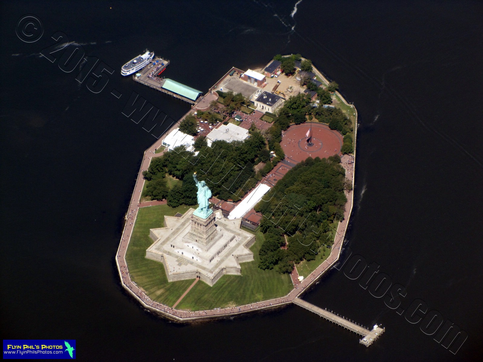
#14 - Liberty Island and the
Statue of Liberty |
 |
| #15 - Statue of Liberty |
 |
#16 - Ellis Island (left), Liberty
State Park and Central Railroad
of New Jersey Terminal
(historical; lower-right) |
 |
| #17 - Ellis Island |
 |
#18 - Jersey City Hudson river
waterfront high-rise buildings, NJ |
 |
#19 - Hudson Bay with
Governors Island (center) looking
south towards the Verrazano bridge
and Sandy Hook, NJ |
 |
| #20 - Governors Island, NY |
 |
#21 - Lower Manhattan, NY and
the Hudson (lower) and
East rivers
|
--------------------------------------------------------
The following (4) photos are of the
newly reconstructed World Trade Center
at Ground Zero, Lower Manhattan, NY
 |
| #22 - Freedom Tower (looking west) |
 |
#23 - Freedom Tower and
reflecting pools at Ground Zero |
 |
#24 - Freedom Tower and
reflecting pools at Ground Zero |
 |
#25 - Reflecting Pools and
memorial at Ground Zero
|
--------------------------------------------------------
 |
#26 - Brooklyn bridge (lower)
and Manhattan bridge crossing
the East river connecting
Manhattan with Long Island, NY |
 |
#27 - The Hudson Bay and Lower
Manhattan (looking southwest)
with Governors Island, Ellis Island,
Liberty Island and Liberty State Park |
 |
#28 - Manhattan Island, NY
(looking north) |
 |
#29 - The Empire State building,
Manhattan Island, NY |
 |
#30 - New high-rise at
432 Park Avenue , the tallest
residential tower in the western
hemisphere, Manhattan Island, NY |
 |
#31 - Roosevelt Island in the
East River, NY
|
 |
#32 - Central Park within
Manhattan, NY |
 |
#33 - Metropolitan Museum of Art,
Manhattan, NY |
 |
#34 - Museum of Natural History,
Manhattan, NY |
 |
#35 - Central Park (looking north),
Manhattan, NY |
 |
#36 - Astoria (Long Island, NY),
Roosevelt Island, Manhattan Island,
the Hudson river and
North Bergen, NJ (looking west) |
 |
#37 - Triborough bridge (I-278)
and railroad bridge, crossing the
East River, NY |
 |
#38 - Laguardia airport on
Long Island, NY |
 |
#39 - Nearly (20) aircraft await
their turn for take-off at
Laguardia airport, NY |
 |
#40 - Remains of Flushing airport
(now closed for many years),
is not far from Laguardia airport, NY |
 |
#41 - Citi Field (aka Shea Stadium)
in Flushing Meadows-Corona Park,
Long Island, NY |
 |
#42 - Flushing Meadows-Corona
Park, Long Island, NY |
 |
#43 - Freedom of the Human Spirit
fountain within Flushing Meadows-
Corona Park, NY |
 |
#44 - Arthur Ashe Stadium
within Flushing Meadows-
Corona Park, NY |
 |
#45 - North Shore Towers and
Country Club, Long Island, NY |
 |
#46 - Glen Oaks housing complex,
Long Island, NY |
 |
#47 - Republic airport and adjacent
St Charles/Resurrection Cemeteries
in Farmingdale, Long Island, NY |
 |
#48 - St Charles/Resurrection
Cemeteries |
 |
#49 - Beth Moses Cemetery (top),
Industrial Park (center) and
New Montefiore Cemetery (bottom)
in Farmingdale, Long Island, NY |
 |
#50 - Westfield South Shore
shopping mall in Bay Shore,
Long Island, NY |
 |
#51 - Westfield South Shore
shopping mall |
 |
#52 - Connetquot River
State Park (far) and Bohemia
County Park (near) within the
large, wooded area near
Ronkonkoma, Long Island, NY |
 |
#53 - Long Island MacArthur airport
in Ronkonkoma, NY |
 |
#54 - MacArthur airport
passenger terminal |
 |
#55 - Large clearing within the
Rocky Point State Pine Barrens
Preserve near Rocky Point,
Long Island, NY
|
--------------------------------------------------------
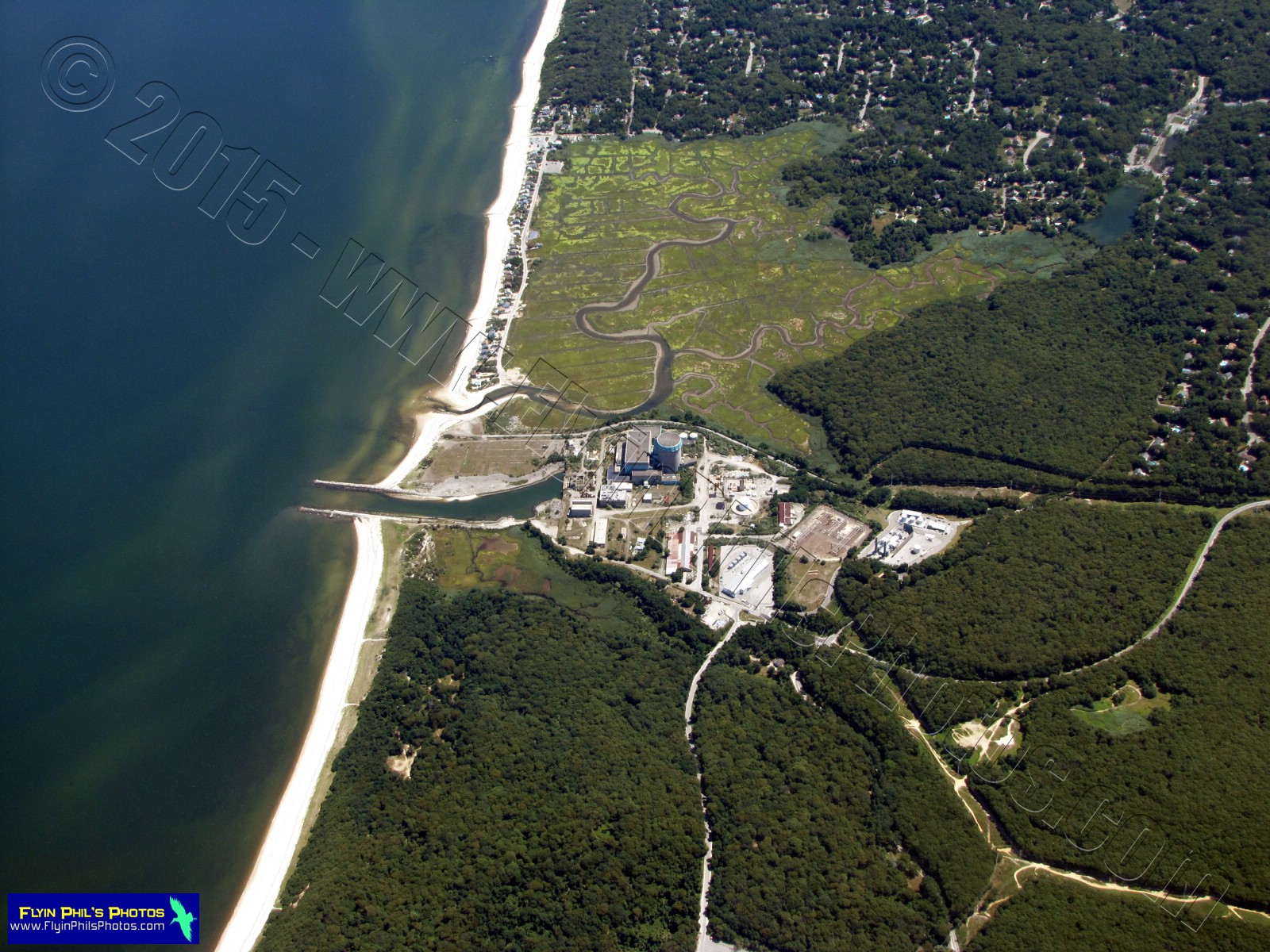
The following (3) photos are of the
Shoreham Nuclear Power Plant
that was built between 1973-1984
but never operated
 |
#56 - Shoreham Nuclear
Power Plant looking northeast
along the north shore of
Long Island, NY |
 |
| #57 - Shoreham Nuclear Power Plant |
 |
| #58 - Shoreham Nuclear Power Plant |
--------------------------------------------------------
 |
#59 - North Fork of Long Island,
looking northeast |
 |
#60 - Calverton Executive Airpark
in Riverhead, Long Island, NY |
--------------------------------------------------------
The following (5) photos are of
Brookhaven National Laboratory
in Upton, Long Island, NY
 |
#61 - Overview of the site
(looking northeast) |
 |
#62 - Overview of the site
(looking southeast) |
 |
#63 - Overview of the site and
the High Flux Beam Reactor |
 |
| #64 - Relativistic Heavy Ion Collider |
 |
#65 - National Syncroton
Light Source II
|
--------------------------------------------------------
 |
#66 - Brookhaven airport
(looking southeast) in
Shirley, Long Island, NY |
 |
#67 - Large general aviation
parking area at Brookhaven airport |
 |
| #68 - Town of Shirley, NY |
 |
#69 - Heckscher State Park in
Great River, Long Island, NY |
 |
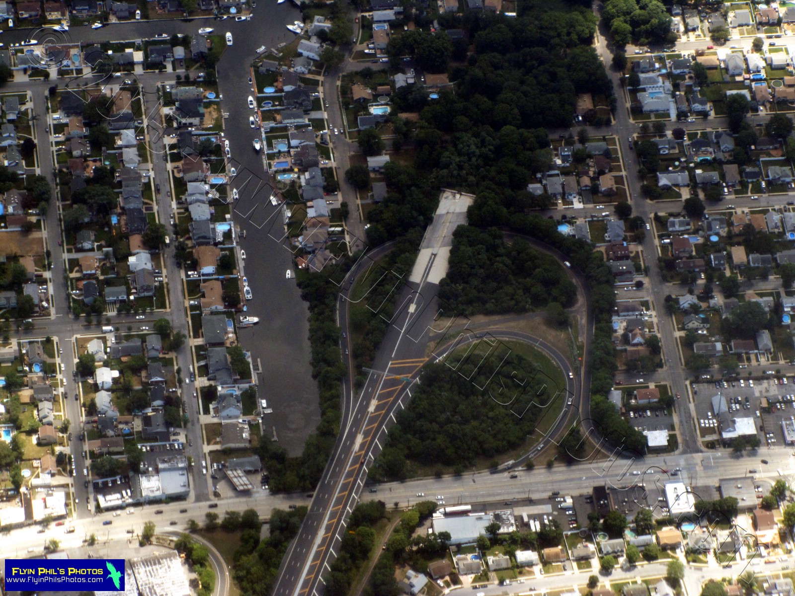
#70 - Robert Moses Causeway
crossing the Oak Island and
Dickerson Channel |
 |
#71 - Robert Moses Causeway
bridge with speed boat passing
underneath |
 |
#72 - Robert Moses State Park (far)
and Gilgo State Park / Cedar Beach
Park (near), Long Island, NY |
 |
#73 - Bamboo Island (right) and
Cedar Beach Park (far),
Long Island, NY |
 |
#74 - Bergen Point Golf Course and
Bergen Point Wastewater
Treatment Plant (far) in
West Babylon, Long Island, NY |
 |
#75 - Enormous marina adjacent
to the Fox Creek Channel in
Lindenhurst, Long Island, NY |
 |
#76 - Jones Beach Causeway
and Jones Beach (upper-left) on
Long Island, NY |
 |
#77 - Town of Seaford and
Jones Beach Causeway (right)
looking east towards Jones Beach,
Long Island, NY |
 |
#78 - Route 135 dead-ends in
Seaford, Long Island, NY |
 |
#79 - Merrick train station in
Merrick, Long Island, NY |
 |
#80 - Norman J. Levy Park and
Preserve adjacent to the
Merrick Golf Course in
Merrick, Long Island, NY |
 |
#81 - Belmont Park Race Track
in Elmont, Long Island, NY
|
--------------------------------------------------------
The following (8) photos are of
John F. Kennedy (JFK)
International airport on Long Island, NY
 |
| #82 - Looking southeast |
 |
#83 - Construction on two runways,
looking southeast |
 |
#84 - Overview of JFK
International airport |
 |
#85 - Overview of JFK
International airport |
 |
#86 - Overview of JFK
International airport passenger
terminals and automobile access |
 |
#87 - Overview of JFK
International airport passenger
terminals and automobile access |
 |
#88 - Control tower and
passenger terminal |
 |
#89 - Overview of JFK International
airport, looking east
|
-------------------------------------------------------
 |
#90 - Floyd Bennet Field on Barren
Island within Long Island, NY
(looking southeast) |
 |
#91 - Floyd Bennet Field,
looking southeast |
 |
#92 - South shore of Long Island,
looking northeast from
Breezy Point, NY |
 |
93 - The Jersey Shore and
Asbury Park, NJ |
 |
| #94 - Asbury Park boardwalk, NJ |
 |
#95 - National Guard Training Center
in Sea Girt, NJ |
 |
#96 - The Jersey Shore, looking
north from Point Pleasant, NJ |
 |
#97 - The Jersey Shore, looking
north from Seaside Park, NJ |
 |
#98 - Island Beach State Park (near)
and Long Beach Island (far),
along the Jersey Shore |
 |
#99 - Seaside Heights boardwalk
and amusements with
Pelican Island (left-center)
within the Barnegat Bay |
 |
#100 - West Point Island within
the Barnegat Bay, near
Ortley Beach, NJ
|
--------------------------------------------------------
See you after the next flight...