
When contacting me about a particular photo(s),
always refer to the Post Date, Photo Number and Description.
[Photo #1 is always at the top of the posting]
Remember to Left-Click any photo to open a larger view,
then hit the ESC (escape) button on your keyboard
to return to the BLOG
then hit the ESC (escape) button on your keyboard
to return to the BLOG
--------------------------------------------------------
The total journey encompassed 450+ miles and two of the largest cities in the
Northeastern U.S., Philadelphia, Pennsylvania and of course, Baltimore, Maryland. Being a photographer, I did not want to be bothered calling each city's airport controlling agency and be directed around airline traffic, so as usual when shooting large places like New York City and the like, I spend the time climbing 'over' the city's airport(s) airspace, and today was no different. I am dividing this day's flight into two parts (1 and 2) due to the amount of photos of each major metropolitan area.
Part 1 is the first leg of the journey, from Hunterdon County in New Jersey, south to areas just east of Trenton, climbing to 8,000 feet over Philadelphia, over to Wilmington, Delaware and finally to a small airport
in northern Delaware for a fuel stop.
Part 2 is the second and third legs from Delaware, climbing to 10,800 feet over Baltimore, then turning north over the vast fields of Delaware, continuing over the expansive Delaware river near southern New Jersey and culminating with some more impressive views closer to home in central New Jersey.
As always, I hope you enjoy the view from above...
PART 1 - Philadelphia (64 Photos)
PART 1 - Philadelphia (64 Photos)
---------------------------------------------------
 |
| #1 - Morning clouds in the Delaware river valley near Frenchtown, NJ |
 |
| #2 -Traffic STOPPED southbound on the New Jersey Turnpike near the Bordentown, NJ rest area |
 |
| #3 - Philadelphia, PA (right) and Camden, NJ (left) in the distance |
---------------------------------------------------
The next (31) photos are of Philadelphia, PA
[description included where appropriate]
 |
| #4 - Looking south |
 |
| #5 |
 |
| #6 |
 |
| #7 |
 |
| #8 |
 |
| #9 |
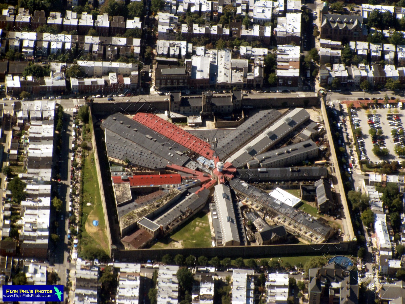 |
| #10 - Eastern State Penitentiary |
 |
| #11 - Philadelphia Museum of Art |
 |
| #12 - Philadelphia Zoo (half moon shape on right) |
 |
| #13 - Looking southeast along the Schuylkill river |
 |
| #14 - Rail yard and train station west of the city |
 |
| #15 - Looking northeast along the Delaware river |
 |
| #16 |
 |
| #17 - Train station west of the city |
 |
| #18 |
 |
| #19 - It's unbelievable that what you see is not a rock landscape, but thousands of people's homes |
 |
| #20 - Zooming-in a bit, one can just make out the individual row houses |
 |
| #21 - Adventure Aquarium and the the Battleship New Jersey in Camden, NJ (looking northwest) |
 |
| #22 - Adventure Aquarium and the the Battleship New Jersey in Camden, NJ (looking south) |
 |
| #23 - Philadelphia Seaport |
 |
| #24 |
 |
| #25 |
 |
| #26 - Philadelphia Seaport and I-95 (looking south) |
 |
| #27 - Looking south |
 |
| #28 - The Benjamin Franklin bridge |
 |
| #29 |
 |
| #30 |
 |
| #31 - Suburbs of Philadelphia to the west |
 |
| #32 |
 |
| #33 - Again, those row houses are simply incredible to view from the air |
 |
| #34 - University of Pennsylvania |
---------------------------------------------------
Now we break away from the city
itself in the next (3) photos
 |
| #35 - Looking northwest along the Schuylkill river near Conshohocken, PA |
 |
| #36 |
 |
| #37 - Intersection of I-76 / Route 1 and their respective bridges over the Schuylkill river |
---------------------------------------------------
The next (6) photos are of areas south
of the city itself
 |
| #38 - Ship yard near the Walt Whitman bridge |
 |
| #39 - South Philadelphia Sports Complex |
 |
| #40 - Philadelphia Naval Business Center |
 |
| #41 - Philadelphia Naval Business Center |
 |
| #42 - Two out-of-commission aircraft carriers and a dry dock at the Philadelphia Naval Business Center on the Delaware river |
 |
| #43 - Bridge carrying the I-95 Delaware expressway over the Schuylkill river |
---------------------------------------------------
The next (5) photos show many views
of Philadelphia International airport
 |
| #44 - Looking southeast |
 |
| #45 - Looking northeast |
 |
| #46 - Terminal area |
 |
| #47 - Looking northeast |
 |
| #48 - Looking north |
---------------------------------------------------
 |
| #49 - One FINAL view of Philadelphia and surrounding area (looking north) |
 |
| #50 - Mobil (tm) refinery in Paulsboro, NJ |
 |
| #51 - Spitfire Aerodrome in Salem County, NJ |
 |
| #52 - Interchange of I-495 and Route 3 in Wilmington, DE |
---------------------------------------------------
The next (7) photos are of the city
of Wilmington, Delaware
 |
| #53 -Looking southwest |
 |
| #54 |
 |
| #55 |
 |
| #56 |
 |
| #57 - Wilmington Riverfront Park |
 |
| #58 - Looking northeast at Wilmington with the Delaware Memorial bridge at the upper-right |
 |
| #59 |
---------------------------------------------------
 |
| #60 - A massive Interchange in New Castle, DE of I-95 and Routes 141 and 202 |
 |
| #61 - The same interchange above, plus the interchange of I-95, I-295, I-495 and Route 202 to the northwest |
 |
| #62 -The Delaware Memorial bridge over the Delaware river, linking the towns of Pennsville, NJ and New Castle, DE |
 |
| #63 - New Castle county airport, DE |
 |
| #64 - Summit airport in Middletown, DE |
---------------------------------------------------
See you after the next flight...