
When contacting me about a particular photo(s),
always refer to the Post Date, Photo Number and Description.
[Photo #1 is always at the top of the posting]
Remember to Left-Click any photo to open a larger view,
then hit the ESC (escape) button on your keyboard
to return to the BLOG
then hit the ESC (escape) button on your keyboard
to return to the BLOG
--------------------------------------------------------
The total journey encompassed 450+ miles and two of the largest cities in the
Northeastern U.S., Philadelphia, Pennsylvania and of course, Baltimore, Maryland. Being a photographer, I did not want to be bothered calling each city's airport controlling agency and be directed around airline traffic,
so as usual when shooting large places like New York City and the like,
I spend the time climbing 'over' the city's airport(s) airspace, and today was no different. I am dividing this day's flight into two parts (1 and 2) due to the amount of photos of each major metropolitan area.
Part 1 is the first leg of the journey, from Hunterdon County in New Jersey, south to areas just east of Trenton, climbing to 8,000 feet over Philadelphia, over to Wilmington, Delaware and finally to a small airport
in northern Delaware for a fuel stop.
Part 2 is the second and third legs from Delaware, climbing to 10,800 feet over Baltimore, then turning north over the vast fields of Delaware, continuing over the expansive Delaware river near southern New Jersey and culminating with some more impressive views closer to home in central New Jersey.
As always, I hope you enjoy the view from above...
PART 2 - Baltimore (74 Photos)
PART 2 - Baltimore (74 Photos)
---------------------------------------------------
 |
| #1 - Lonely clouds and their reflection on the Chesapeake Bay |
 |
| #2 -The Schuylkill River dumping into the Chesapeake Bay |
 |
| #3 - Two rail lines and Route 40 (Pulaski highway) bridges over the Schuylkill river |
 |
| #4 - Edgewood, MD and the Chesapeake Bay (looking southeast) |
 |
| #5 - The vast Chesapeake Bay |
 |
| #6 - A heliport within the Aberdeen Proving Grounds Military Reservation |
 |
| #7 - Looking northeast at Middle River and the northernmost section of the Chesapeake Bay |
 |
| #8 - The towns of Middle River and Bowleys Quarters (looking northeast) |
 |
| #9 - Glenn L. Martin State Airport in Middle River, MD |
 |
| #10 - Looking northeast across Hawk Cove, part of the Chesapeake Bay |
 |
| #11 - The Baltimore Beltway Outer Loop (I-695) bridge over the Chesapeake Bay |
The next (4) photos are of Baltimore's
more industrious harbor area
 |
| #12 - Looking southeast at the Outer Loop bridge (see above) and the Dundalk Marine Terminal |
 |
| #13 - Dundalk Marine Terminal |
 |
| #14 - Entrances to the Fort McHenry Tunnel (I-95) and the Harbor Tunnel Throughway (I-895) |
 |
| #15 - Point Breeze Industrial Park |
---------------------------------------------------
The next (20) photos feature the city
of Baltimore, Maryland
[description added where appropriate]
 |
| #16 -Baltimore (looking west) |
 |
| #17 - A very short highway section of Route 40 exiting the city of Baltimore |
 |
| #18 - Northwest Harbor and the entrance to the Inner Harbor |
 |
| #19 - Same area as above except Patterson park is shown in a densely populated area north of the city |
 |
| #20 - Patterson park |
 |
| #21 - Northwest Harbor |
 |
| #22 - Fort McHenry National Monument and Historic Shrine |
 |
| #23 |
 |
| #24 - Looking southwest at a vast amount of interstate highways, with most leading to the Washington, D.C. area |
 |
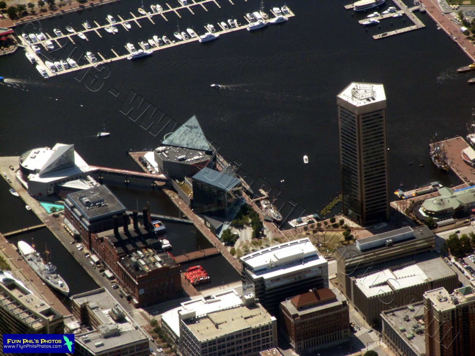
| #25 -Baltimore's Inner Harbor |
 |
| #26 - The Inner Harbor and the Interchange of I-95 and I-395, completely over a section of the Chesapeake Bay |
 |
| #27 - The Inner Harbor |
 |
| #28 - City of Baltimore, MD |
 |
| #29 - Inner Harbor |
 |
| #30 - A close-up view of the Inner Harbor |
 |
| #31 |
 |
| #32 |
 |
| #33 |
 |
| #34 - M and T Bank Stadium (top) and Oriole Park at Camden Yards Stadium (bottom) within the city of Baltimore |
 |
| #35 |
 |
| #36 - From a distance, the Baltimore-Washington International airport |
 |
| #37 |
 |
| #38 - A newly refurbished highway interchange of I-95 and I-695, north of Baltimore, in Rosedale |
 |
| #39 - A sweeping highway interchange of I-695 and Route 702 in Essex, MD |
 |
| #40 - Another view of the Glenn L. Martin State Airport |
 |
| #41 - Numerous aircraft hangars now exist on what used to be runways |
 |
| #42 - Looking south at the Sparrows Point Industrial Complex (upper-left) and the Black river, along with Essex Skypark |
 |
| #43 - Essex Skypark |
 |
| #44 - One FINAL view of Baltimore and surrounding areas (looking west) |
 |
| #45 - Massive waste water treatment facility northeast of Baltimore |
The next (3) photos are of the
Towson, Maryland area, just
north of Baltimore
 |
| #46 - City of Towson |
 |
| #47 - City of Towson |
 |
| #48 - Mount Pleasant Golf Course (lower-center), looking north |
 |
| #49 - Chestertown, MD and the Chester river, winding its way through the many scenic fields that exist there |
 |
| #50 - Chestertown, MD |
 |
| #51 - Route 213 bridge over the Chester river at Chestertown, MD |
 |
| #52 - A layer of scattered clouds at 3,000 feet above the farm fields of Delaware/Maryland |
 |
| #53 - Delaware Airpark in the town of Cheswold, DE |
 |
| #54 - Marshlands on the south shore of the Delaware river, north of the city of Dover |
 |
| #5- Bombay Hook National Wildlife Refuge in Smyrna, DE |
 |
| #56 - Bombay Hook National Wildlife Refuge |
 |
| #57 |
 |
| #58 - Oil / Gas tanker ship traveling south along the Delaware river |
 |
| #59 - The Salem Nuclear Power Plant in the distance, near Salem, NJ |
 |
| #60 - Lush farm fields along the north shore of the Delaware river in southern New Jersey |
 |
| #61 - Bridgeton, NJ |
 |
| #62 - Bridgeton, NJ |
 |
| #63 - South Woods State Prison in Bridgeton, NJ |
 |
| #64 - Radio-Controlled, model aircraft flying field near Bridgeton, NJ |
 |
| #65 - School buses in Berlin, NJ |
 |
| #66 - Tractor trailer storage yard in southern NJ |
 |
| #67 - Picturesque, flowery fields in southern NJ |
 |
| #68 |
 |
| #69 - Solar farm in southern NJ |
 |
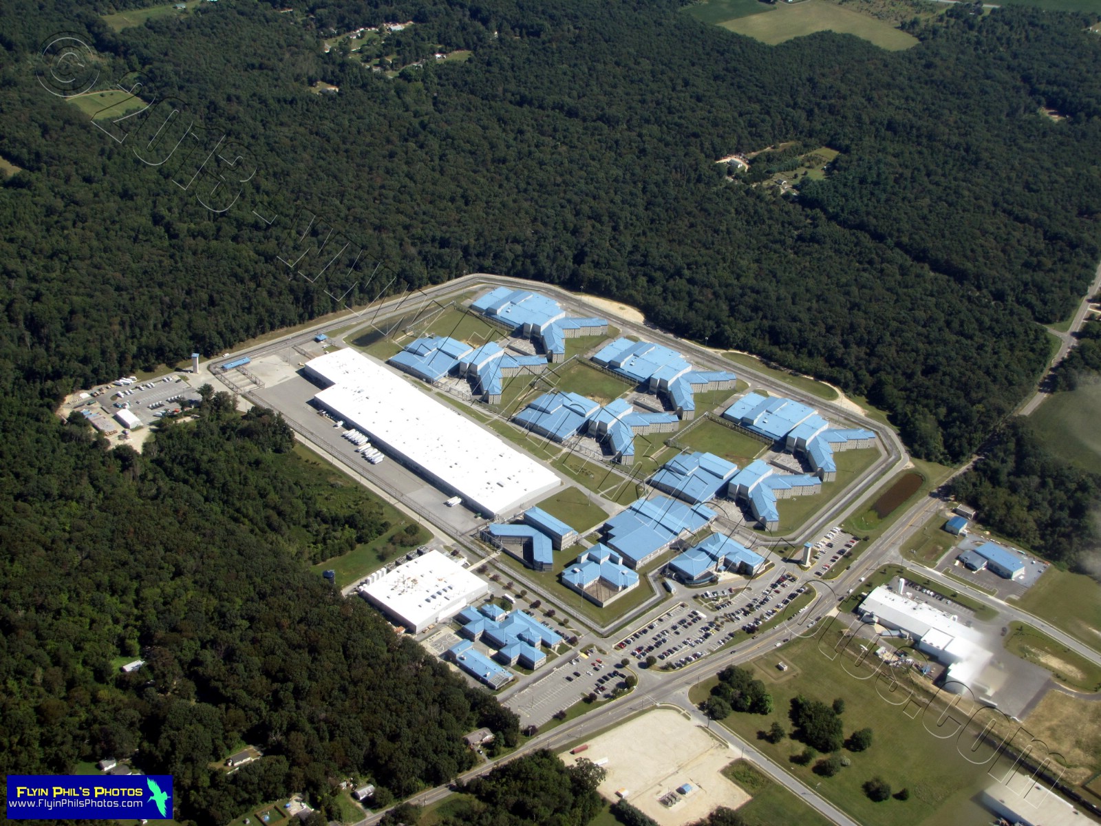
| #70 - Prison complex south of Bordentown, NJ |
 |
| #71 - Newer section of the Bordentown prison complex |
 |
| #72 - A fair was taking place in Central Mercer County Park near Princeton Junction, NJ |
 |
| #73 - Here you can see the many carnival-type rides of the Mercer County Park fair |
 |
| #74 - And last but not least, a field and structures within yet another field... |
See you after the next flight...